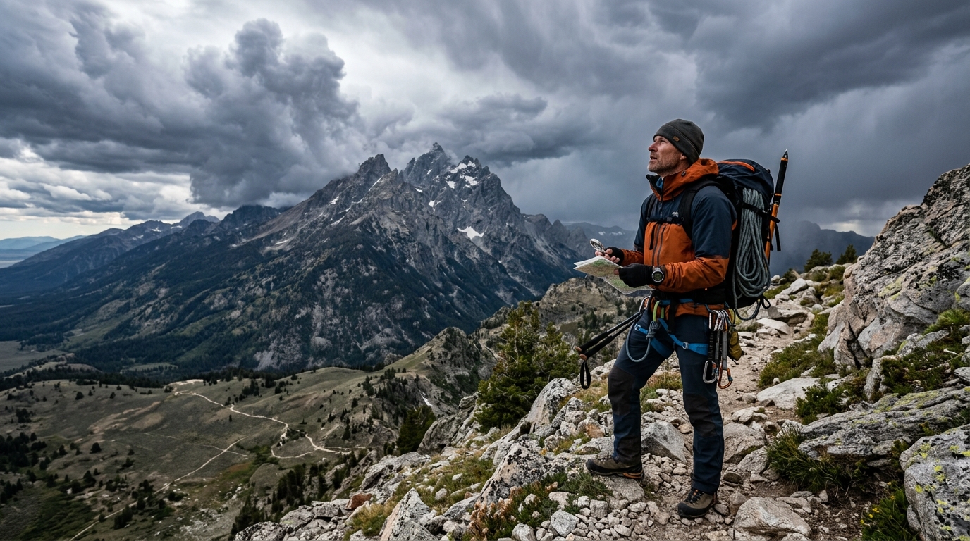
The Tetons don’t forgive ignorance about weather. A sunny morning at the trailhead can turn into a life-threatening lightning storm by noon, and the difference between a memorable summit and a rescue operation often comes down to reading the signs correctly.
Grand Teton weather changes faster than almost anywhere in the Lower 48. This guide teaches you to interpret [local forecasts](https://www.weather.gov/riw/), recognize dangerous cloud formations, understand elevation-based microclimates, and use the tools that experienced climbers and backcountry travelers rely on to make safe decisions in the Teton Range.
Why Teton Weather Is Different from Anywhere Else You’ve Hiked
The Tetons rise 7,000 vertical feet from the valley floor with no foothills to soften the blow.
That abrupt elevation gain creates weather patterns you won’t find in gentler mountain ranges. Storms build with shocking speed. Temperature swings of 40 degrees between morning and afternoon are normal. What works in the Rockies or Cascades won’t keep you safe here.
The range sits at the convergence of three major weather systems. Pacific storms arrive from the west. Cold Canadian air drops from the north. Warm, moist air pushes up from the Gulf of Mexico. When these systems collide over the peaks, conditions become unpredictable and dangerous.
Elevation matters more here than in most ranges. The difference between 6,500 feet at Jenny Lake and 13,770 feet on the Grand’s summit isn’t just temperature. It’s entirely different weather happening at the same moment.
Understanding the Three Elevation Zones
The Tetons operate in distinct weather bands that change as you climb.
Valley floor (6,000 to 7,500 feet): This is where most trailheads sit. Weather here gives you a baseline but tells you almost nothing about conditions higher up. Summer mornings start cool, often in the 40s. Afternoons warm into the 70s or 80s. Thunderstorms typically arrive between 2 and 4 PM.
Mid-elevation (7,500 to 10,500 feet): This zone includes popular destinations like Amphitheater Lake and the lower approaches to major climbs. Temperatures run 10 to 20 degrees cooler than the valley. Snow can fall any month of the year. Storms hit harder and linger longer.
Alpine zone (above 10,500 feet): The summits live in a different world. Winds regularly exceed 50 mph. Temperatures rarely climb above freezing even in July. Lightning becomes the primary danger during afternoon storms. Hypothermia can set in during summer if you’re caught unprepared.
Most accidents happen when climbers misjudge which zone they’re in or fail to account for transitions between zones.
The Daily Weather Cycle You Need to Memorize
Teton weather follows a predictable pattern during stable periods.
-
Dawn to 9 AM: Clearest conditions of the day. Temperatures at their coldest. Winds typically calm. This is your window for technical climbing and exposed ridges.
-
9 AM to noon: Warming begins. Cumulus clouds start forming over peaks. Winds pick up as the day heats the valley floor. Still generally safe for most objectives.
-
Noon to 4 PM: Danger zone. Thunderstorms build over the high peaks and move east across the range. Lightning, hail, and sudden temperature drops become serious threats. You want to be off summits and exposed areas by 1 PM at the latest.
-
4 PM to sunset: Storms typically move east into the valley. Conditions improve in the mountains but can remain unsettled. Late afternoon often brings a second wind of good weather.
-
Sunset to dawn: Temperatures plummet. Clear nights can drop below freezing even in summer. Cloudy nights stay warmer but may indicate incoming weather systems.
This cycle breaks down when larger storm systems move through. That’s when you need better forecasting tools.
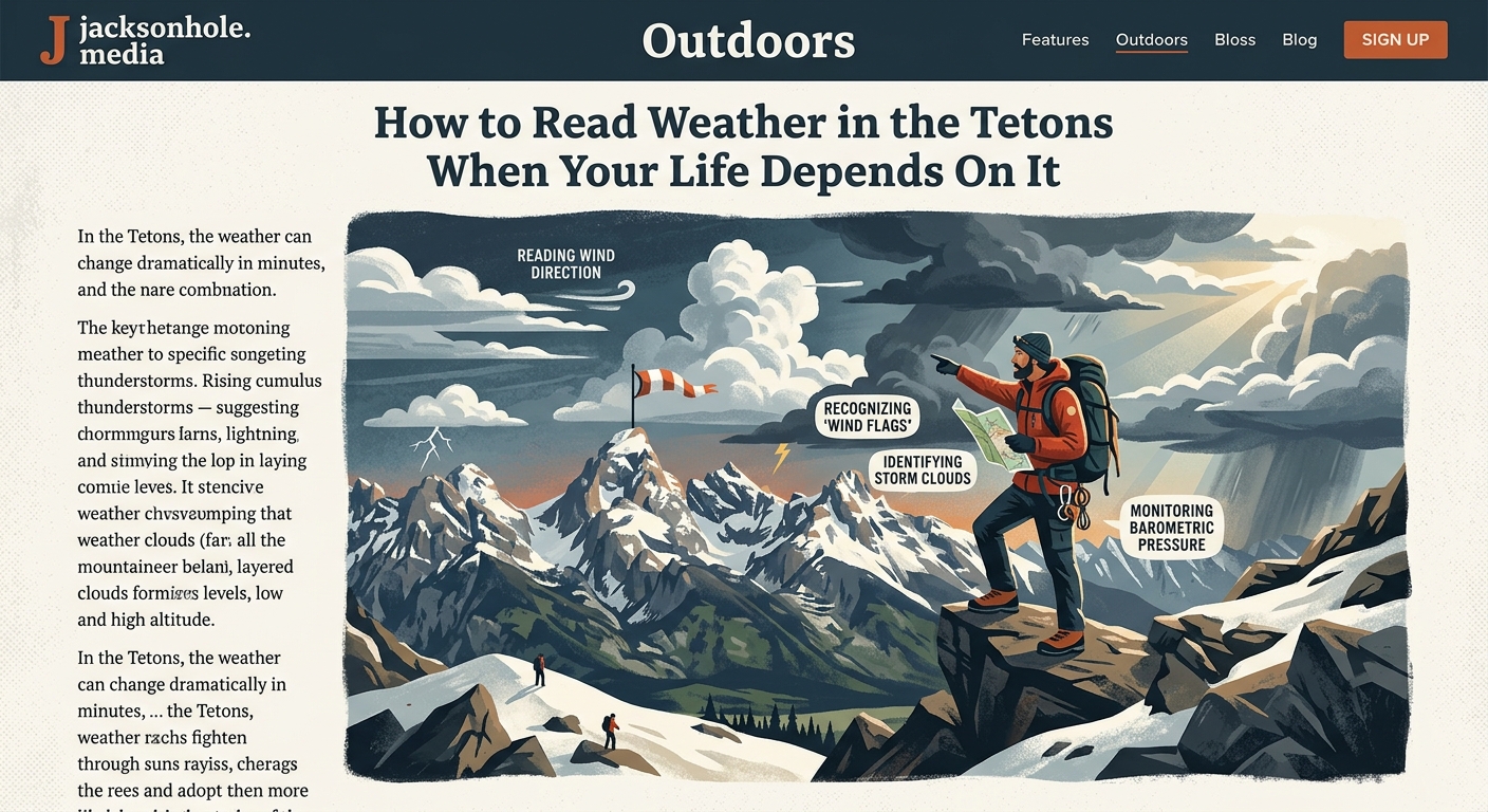
Reading Clouds Like Your Life Depends on It
Cloud formations tell you what’s coming before any weather app.
Morning clouds that look like cotton balls (fair-weather cumulus) are normal. They indicate stable conditions and usually dissipate by evening. When those clouds start building vertically into towers (cumulus congestus), storms are developing. If the tops flatten into anvil shapes (cumulonimbus), lightning is imminent and you need to get to safety immediately.
Lenticular clouds stacked over the peaks like UFOs signal strong winds aloft. These lens-shaped formations mean conditions are unstable and deteriorating. Plan for high winds and potential storms within 12 to 24 hours.
A solid gray ceiling moving in from the west (stratus or nimbostratus) usually brings steady precipitation. Unlike afternoon thunderstorms, these systems can last for days.
Cirrus clouds (thin, wispy, high-altitude) often precede major weather changes by 24 to 48 hours. They’re your early warning system.
“I’ve guided in the Tetons for 22 years, and the single biggest mistake I see is people ignoring what the sky is telling them. Your phone might say sunny all day, but if you see towers building at 10 AM, you turn around. No summit is worth getting struck by lightning.” (Local climbing guide, name withheld)
The Forecasting Tools That Actually Work Here
National Weather Service forecasts for Jackson Hole give you the valley picture but miss crucial mountain details.
The NWS point forecast tool lets you check specific elevations. Pull up forecasts for 6,500 feet, 9,000 feet, and 12,000 feet separately. Compare all three before making decisions.
Mountain-Forecast.com provides elevation-specific predictions for major peaks. The six-hour breakdowns show you exactly when conditions deteriorate. Pay special attention to freezing levels, precipitation timing, and wind speeds at summit elevation.
NOAA weather radio broadcasts updated conditions every few minutes. The signal reaches most of the park. A small weather radio weighs a few ounces and provides real-time updates when you’re out of cell range.
The Bridger-Teton Avalanche Center operates year-round and tracks mountain weather patterns even outside snow season. Their observations include high-elevation wind, precipitation, and temperature data that general forecasts miss.
Local knowledge beats technology. Rangers at Jenny Lake and Lupine Meadows update their whiteboards daily with current mountain conditions. Stop and read them. Talk to climbers coming down. Ask what they saw higher up.
Seasonal Weather Patterns Worth Knowing
Each season brings distinct challenges in the Tetons.
Spring (April to June): Highly unstable. Warm valley temperatures clash with winter conditions above 9,000 feet. Afternoon storms intensify. Snowpack remains significant on most routes into June. Avalanche danger persists through May. Freezing levels fluctuate wildly.
Summer (July to August): Most stable period, but that’s relative. Afternoon thunderstorms are nearly guaranteed. Mornings offer the best weather. Snow clears from most trails by mid-July. Temperatures in the alpine rarely exceed 50 degrees. Hypothermia remains a real risk.
Fall (September to October): Increasingly unpredictable. Multi-day storm systems become common. First significant snow typically arrives in mid-September. Temperature swings intensify. Some of the best weather happens in September, but conditions can flip to winter overnight.
Winter (November to March): Extreme cold, deep snow, and avalanche danger dominate. Only experienced winter mountaineers should attempt backcountry travel. Temperatures at altitude regularly hit -20°F or colder. Winds create dangerous wind chill. Days are short.
The shoulder seasons (May, June, September, October) offer the most dramatic weather swings and require the most careful planning.
Common Forecasting Mistakes That Get People in Trouble
| Mistake | Why It’s Dangerous | Better Approach |
|---|---|---|
| Checking only valley weather | Conditions 7,000 feet higher are completely different | Always check elevation-specific forecasts |
| Ignoring afternoon storm timing | “We’ll be down by then” rarely works out | Start alpine objectives before dawn, summit by noon |
| Trusting a single forecast source | Models disagree frequently in complex terrain | Compare NWS, Mountain-Forecast, and local observations |
| Underestimating wind chill | 40°F with 40 mph winds feels like 28°F | Calculate wind chill for summit conditions, pack accordingly |
| Assuming summer means warm | Alpine temps stay near freezing year-round | Bring insulation even for July climbs |
| Ignoring cloud development | Towers at 11 AM become lightning by 1 PM | Turn around when cumulus starts building vertically |
What to Pack Based on the Forecast
Your gear list should respond directly to predicted conditions.
For stable, clear forecasts with light winds, you can trim weight. Still bring a rain shell and insulation layer. Afternoon storms materialize even on “clear” days.
When forecasts show any chance of precipitation, pack full rain gear and extra insulation. Wet plus cold equals hypothermia faster than most people realize. A 50-degree rain in the alpine can be life-threatening.
High wind predictions require additional layers, wind-resistant shells, and goggles or glasses to protect your eyes. Wind dramatically increases caloric burn and dehydration.
Uncertain forecasts demand full preparedness. Bring bivy gear or emergency shelter. Pack extra food and fuel. Carry headlamps with fresh batteries. Plan bailout routes before you start.
The old climbing adage applies here more than anywhere else. Pack for the worst conditions possible, hope for the best, and be ready to turn around when reality falls somewhere in between.
Lightning Safety in the High Peaks
Afternoon thunderstorms in the Tetons produce some of the most intense lightning in North America.
The 30-30 rule applies. When you see lightning, count seconds until you hear thunder. If it’s 30 seconds or less (about six miles), the storm is close enough to strike you. Seek shelter immediately. Wait 30 minutes after the last thunder before resuming activity.
Get off summits, ridges, and exposed areas at the first sign of electrical activity. Don’t wait for rain or close strikes. Descend to lower elevations or seek shelter in low areas away from tall objects.
Avoid caves and overhangs less than five feet deep. Electrical current can arc across shallow openings. True caves with deep interiors provide safety, but most Teton “caves” are just overhangs.
The lightning position (crouched on the balls of your feet, minimizing ground contact) is a last resort. Your priority is getting to safer terrain, not assuming a position that makes you feel better while remaining in danger.
Metal gear doesn’t attract lightning, but it conducts it. Distance yourself from large metal objects like backpacks with frames during active electrical storms.
If someone in your group is struck, begin CPR immediately. Lightning victims carry no electrical charge and are safe to touch. Many survive with immediate medical intervention.
When to Change Your Plans
The hardest weather decision is calling off an objective you’ve planned for months.
Change plans when forecasts show storms arriving earlier than the typical afternoon window. If thunderstorms are predicted before noon, you won’t have time to safely complete and descend from alpine routes.
Scrap summit attempts when sustained winds above 10,000 feet exceed 40 mph. You can’t maintain body temperature or make good decisions in that kind of wind exposure.
Postpone when freezing levels drop below your objective’s elevation combined with precipitation. Wet snow or ice on technical terrain multiplies danger exponentially.
Bail when conditions on the mountain differ significantly from the forecast in a negative direction. If clouds are building at 9 AM when forecasts predicted clear until 2 PM, trust what you see, not what you hoped for.
The mountains will be here tomorrow. They’ve been here for millions of years. They’ll wait for better conditions.
Microclimates and Local Weather Quirks
Certain areas within the Tetons create their own weather patterns.
The west slopes (Idaho side) receive more precipitation than the east. Storms moving from the Pacific dump moisture as they rise over the range. The Wyoming side often stays drier during the same event.
Canyons and gullies funnel and intensify winds. What feels like a 20 mph breeze on open terrain can gust to 50 mph in a narrow couloir.
South-facing slopes warm faster and shed snow earlier but also build unstable snow conditions in spring. North-facing slopes hold snow longer and stay colder throughout the day.
Cascade Canyon creates its own wind tunnel effect. Afternoon breezes accelerate through the canyon, making conditions significantly windier than surrounding areas.
The lakes moderate temperature near their shores. Jenny Lake, Leigh Lake, and Jackson Lake create slightly warmer microclimates within a few hundred yards of their edges.
Resources Beyond Standard Forecasts
The Jackson Hole Mountain Resort weather station provides real-time data from 10,450 feet. Even if you’re not skiing, their observations show what’s happening at mid-elevation.
The Teton Interagency Dispatch Center updates fire weather forecasts that include detailed wind and humidity data useful for backcountry planning.
Local Facebook groups and forums share real-time observations from people currently in the mountains. Search for Teton climbing or hiking groups. Read recent posts before heading out.
The park’s wilderness office at Moose maintains a conditions board with recent trip reports and ranger observations. Stop there when picking up permits.
Consider taking a wilderness weather course. What it’s really like to spend winter as a ski patrol on Teton Pass offers perspective on how professionals read mountain weather in this region.
Weather Wisdom from People Who Live Here
Locals develop an intuitive sense of Teton weather through years of observation.
Morning valley fog that burns off by 8 AM typically indicates a clear day. Fog that lingers past 9 AM often signals an approaching weather system.
When you can see individual trees on the peaks from the valley floor, the air is dry and conditions are stable. Hazy views mean moisture is building.
Unusually warm overnight temperatures in the valley often precede storms. The warmth comes from cloud cover trapping heat and indicates changing patterns.
Strong winds in Jackson in the morning usually mean even stronger winds in the mountains. Plan accordingly.
Animals behave differently before major weather changes. Increased bird activity and animals moving to lower elevations can signal approaching storms. This isn’t superstition. Wildlife responds to barometric pressure changes before humans notice them.
The ranching community in areas like the Gros Ventre Valley has tracked weather patterns for generations. Their observations about seasonal trends and storm timing carry weight.
Building Your Own Weather Intuition
Reading Teton weather well takes practice and attention.
Keep a weather journal on every trip. Note forecasts, actual conditions, cloud types, wind behavior, and how they matched or differed. Patterns emerge over time.
Photograph the sky throughout the day. Compare morning clouds to afternoon storms. Build a visual library of what different formations mean.
Talk to rangers and experienced climbers. Ask what signs they watch for. Most are happy to share knowledge with people who take safety seriously.
Start with shorter objectives in good conditions. Build experience gradually. Learn what different weather feels like before committing to long, exposed routes.
Study meteorology basics. Understanding why weather happens helps you predict what will happen next. You don’t need a degree, just curiosity and attention.
Making the Call When Conditions Are Marginal
The most common scenario isn’t perfect weather or obvious danger. It’s the gray area in between.
Ask yourself these questions when conditions are uncertain:
- Do I have the gear to survive if conditions deteriorate further?
- Can I retreat safely if weather worsens?
- Am I making this decision based on what I want to be true or what I actually observe?
- Would I make the same call if this were a training climb instead of a bucket list objective?
- What would I tell a friend to do in this situation?
Set turnaround times before you start. Stick to them regardless of how close you are to the summit. Most epic survival stories start with “we were so close, we decided to keep going.”
Trust your gut. If something feels wrong about the weather, it probably is. Your subconscious processes more information than your conscious mind acknowledges.
The best climbers aren’t the most talented or strongest. They’re the ones who make good decisions consistently and live long enough to develop real expertise.
Weather Knowledge Keeps You Coming Back
Learning to read Teton weather transforms how you experience these mountains.
You’ll stop seeing forecasts as permission or prohibition and start seeing them as one data point among many. You’ll develop confidence in your ability to assess conditions independently. You’ll make better decisions about when to push and when to retreat.
Most importantly, you’ll stay safe enough to return. The Tetons reward patience and punish hubris. Understanding their weather patterns is how you tell the difference.
Start checking forecasts for multiple elevations a week before your trip. Watch how patterns develop and change. Compare predictions to reality. Learn from every outing.
The weather here will humble you repeatedly. That’s part of what makes these mountains special. They demand respect, attention, and constant learning. Give them that, and they’ll provide a lifetime of unforgettable experiences.