Most hikers who pull out a map of the Teton backcountry have no idea who drew it. They trace their finger along a faint trail through the Jedediah Smith Wilderness, past an unnamed lake, over a ridge, and down into a drainage that doesn’t appear on any government topo. That line was put there by hand. By a man in his seventies who once mapped oil fields in West Texas but now spends his summers walking the same routes over and over again, pencil and compass in hand. He never asked for permission. He never sought recognition. He just noticed that the maps hikers were using were wrong. So he fixed them.
The story of how a retired geologist became Grand Teton’s most trusted trail cartographer. With no official funding and no social media presence, his hand-drawn maps have become essential tools for backcountry hikers who want accurate, detailed information about the park’s less-traveled paths. His work fills a critical gap left by outdated government surveys and crowdsourced trail apps.
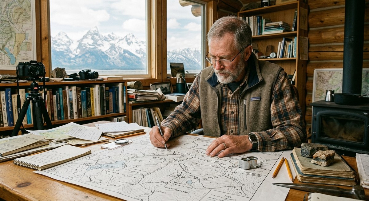
A Lifetime of Reading the Land
Before he ever set foot in Jackson Hole, this man spent thirty years reading rock formations for oil companies. He learned to see the world in layers. He understood how water moves through a valley, how ridges form, and how erosion changes a landscape over decades. That training turned out to be perfect for mapping trails.
When he retired and moved to Teton County in 2015, he did what many retirees do. He started hiking. But he noticed something that bothered him. The trail maps available at the ranger station and online were full of errors. Trails that had been rerouted years ago were still drawn in the old places. Water sources were marked a quarter mile from where they actually sat. Some trails were labeled as easy when they involved steep, exposed scrambling.
He started taking notes on his hikes. Then he started drawing.
How a Retired Geologist Maps a Trail
His process is methodical. It looks nothing like the way modern mapping apps work. Here is how he approaches a new route:
- Walk the trail at least three times in two different seasons. Once in late spring when snowmelt reveals water crossings. Once in late summer when vegetation is thickest. A third time to verify notes.
- Mark every water source with GPS coordinates and a hand-drawn symbol. He notes whether the water is seasonal, reliable, or intermittent. He also tests flow rates during dry spells.
- Record trail surface conditions at half-mile intervals. Loose scree, packed dirt, rooted sections, and exposed bedrock all get different symbols on his maps. He notes which sections become slippery after rain.
- Measure elevation changes with a handheld altimeter, not a phone app. Phone elevation data can vary by hundreds of feet in the Tetons due to tree cover and canyon walls. His altimeter gives him consistent readings within ten feet.
- Draw every switchback and cutoff by hand on a gridded field notebook. He uses a 0.5 mm mechanical pencil so the lines stay thin and precise. He erases and redraws until the curve matches the actual trail.
- Compare his draft against satellite imagery and old USGS quads. If something doesn’t match, he goes back and hikes it again. He trusts his feet more than the satellite.
Each map takes between three and six weeks to complete. He has mapped over forty trails since 2016.
What Makes His Maps Different
National park maps and GPS apps serve a purpose. They get you to the general area. But they miss the details that matter most to backcountry hikers. Here is what his hand-drawn maps include that digital maps often leave out:
- Trail junctions marked with permanent landmarks like a specific dead tree or a distinctive rock formation. If the signpost is missing (which happens often), you still know where to turn.
- Campsite locations rated for wind exposure, proximity to water, and bear activity history. He notes which sites have food storage poles and which do not.
- Sections of trail that become impassable after moderate rain. He marks them with a specific warning symbol so hikers can plan alternate routes.
- Unofficial use trails that connect sections of official trail. These short cuts save miles but require local knowledge. He only includes them if they are safe and sustainable.
- Notes on cell service dead zones, plotted to within a quarter mile. This helps hikers know when to send their final messages before going dark.
“A GPS will tell you where you are. It won’t tell you whether the trail ahead is washed out or whether the creek you’re about to cross is running at flood stage. That takes someone who has stood there and looked at it.” – The cartographer, during a talk at the Teton County Library
Common Mapping Mistakes and How He Avoids Them
After a decade of mapping, he has identified the most common errors that plague Teton backcountry maps. He designed his whole process to avoid them.
| Common Mistake | How He Fixes It |
|---|---|
| Trail shown as open but actually closed by park service | Walks every mile of trail every season. Updates maps within two weeks of any official closure. |
| Elevation gain listed as a single number for the whole trail | Breaks elevation into segments. Shows where the steepest climbs actually occur, not just the total. |
| Water sources marked but dry for most of the summer | Visits each source in July and August. Marks seasonal reliability with a date stamp on the map. |
| Trail difficulty based on distance alone | Rates difficulty by combining distance, elevation change, surface type, and exposure to sun and weather. |
| Maps updated every five to ten years | Updates every single map annually. Sends free PDF updates to anyone who bought a previous version. |
The Community That Formed Around His Work
At first, he gave his maps away to friends. Then friends of friends started asking for copies. By 2020, he was printing maps at a local copy shop and selling them for exactly what it cost to print. He never wanted to make money. He wanted hikers to stay safe.
His maps now show up in gear shops around town. Local guides carry them as backup navigation tools. The volunteer search and rescue team uses his maps during missions because they show trail conditions that official maps miss. In fact, his detailed notes on water sources and trail surfaces have helped Jackson Hole’s volunteer search and rescue team locate lost hikers faster than relying on standard park maps.
He still refuses to take credit. When hikers thank him on the trail, he shrugs and says he just likes walking.
Why the Tetons Need This Kind of Care
The Teton backcountry is changing. Glacial melt has rerouted streams. Wildfire seasons have altered tree cover and created new avalanche paths. Heavy use on popular trails has widened some sections and eroded others. The official maps cannot keep up. The park service does its best with limited resources, but they have hundreds of miles of trails and a tiny mapping staff.
His work fills the gap. It is not official. It is not sanctioned. But it is accurate. And for hikers who plan to spend multiple days in the backcountry, accuracy is not a luxury. It is a safety issue.
He does not plan to stop anytime soon. This summer, he is mapping three new routes in the Teton Wilderness and updating six older maps. He says he will keep going until his knees give out. Given the way he moves through the mountains, that could be another twenty years.
What His Maps Teach Us About the Backcountry
His maps are more than navigation tools. They are records of a place that is always shifting. A trail he mapped in 2018 looks different today. A water source that was reliable for decades dried up after the 2024 drought. A campsite that was peaceful for years now sees heavy bear traffic.
He documents all of it. Not because anyone asked, but because he believes that good information saves lives. He also believes that the Tetons deserve to be seen accurately. Not through the lens of a smartphone app or a generic GPS file, but through the careful observation of someone who has walked every step.
If you want to read more about the people who shape life in this valley, check out the story of the last working cowboys of the Gros Ventre Valley or learn about the barista who knows everyone’s story in downtown Jackson. These are the quiet characters who make Jackson Hole what it is.
The Legacy of a Man Who Just Keeps Walking
He has no website. No Instagram account. No brand. His maps are sold at a single local shop, and you have to ask for them by name. Yet hikers drive from Idaho and Montana just to buy a copy. They know that a hand-drawn map from a retired geologist is worth more than any app on their phone.
Next time you head into the Teton backcountry, take a moment to look at your map. If the lines are precise and the notes are detailed, check the corner. It might have his initials. It might be the work of someone who decided that the Tetons deserved better maps. So he made them himself.
And if you see a gray-haired man sitting on a ridge, pencil in hand, notebook open on his knee, say thank you. He will probably just nod and point toward the trail ahead. But you will know. You will know that you are holding a map drawn by someone who walked that ground so you could find your way.